I had an interesting talk with one of my co-workers the other day. He's been surveying for about twenty years longer than me and other than being a bit long winded (which is the pot calling the kettle black), is quite well versed in not only our current surveying methods, but how it used to be done as well. Any good surveyor is a student of the past, we need to be because we frequently have to use very old data that was measured in very different ways than we do now.
We were looking at a section where a couple of different Records of Survey disagreed with each other by as much as ten feet in the East-West direction and a couple of feet in the North-South. Without going into much detail, when the Public Land Surveying System was developed, any errors that occurred were concentrated ("thrown") into the west-most sections of land. The section we were working in happened to be one of these, so errors and discrepancies aren't without precedent. This lead to a discussion on how the modernization of measurements has made the world smaller, and every step forward in technology makes all our measurements shorter than it's predecessors.
Egyptian rope stretchers used 3-4-5 triangles to relocate survey markers washed away by the yearly floods of the Nile. I have used this exact technique to lay out a parking lot for shipping containers on Blount Island, FL. The locations of the containers have changed and it looks like the parking lot has been paved, but this is the same area. The problem we ran into was that we were using rope that stretched. So the triangles got out of shape over time, and my calculations were slowly skewed so that we didn't get as many parking spaces as I'd first predicted. What happened was that the triangles got bigger due to the stretching, so our 30' x 40' x 50' "right angles" were out of whack.
The first big revolution in measuring technology was the Gunter's Chain. A chain is 100 links, measuring sixty six feet long. Sixty six seems like a strange number, but it divides nicely into a mile eighty times.
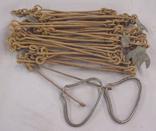 A section is eighty chains, or one mile square. The problem came from having a device sixty six feet long and having to pull it in a straight line for a mile. You would naturally have some kinks in the "straight line" no matter how skilled the chainmen. And any slopes would have to take into consideration the slope distance traveled versus the horizontal distance traveled. There are other considerations as well, such as height above sea level, but I'm not going to go into them. So, as the chainmen measured their miles with their chain, their measurement would always be long due to the inherent inaccuracies of the method. The original General Land Office (now the BLM) surveys of the western US were all done in this manner, using Gunter's Chains.
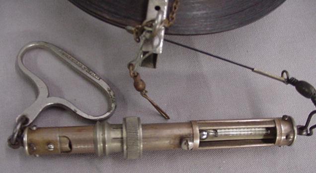
Next comes the steel or invar tape. These were made in lengths up to 300' feet and skilled chainmen using special chain clamps, tension gauges, and chaining "bucks", could get very precise measurements using them. However, the same problem existed, you still had to make several setups to measure, and each of those setups introduced error causing the lengths measured to be long again.
 So, the surveyors using these types of tapes were finding that the measurements of their forebears using chains were always a little longer than what they measured with their tapes. The world had shrunk a bit, and surveyors had to accommodate the changes while still perpetuating the original surveys
Next came electronic distance meters (EDMs), which shrunk the world even more. These became prevalent in the 1970's & omnipresent by the '80s.
 This is about the time I started my surveying career. The only time I have used the earlier instruments is in school and on the occasional side job when an EDM wasn't available. All through my college education for surveying, we used "chains" (which were actually the tapes mentioned above, but nobody calls them that), and theodolites with no electronic capability at all. I remember being amazed at seeing my first EDM when the instructor brought one in to show us. The only electronics I had available to me during school was my HP 41cx I'd bought for work. Since the advent of EDMs, the world has shrunk even more. No longer are we tied to the ground by some sort of rope, chain or tape, now we measure distances by shooting a beam of light to a reflector, and measure the amount of time it takes for it to get back.
  From that we can calculate the distance to the reflector since the speed of light is for all intents & purposes is fixed. Distance equals the speed of light multiplied by the elapsed time divided by two (round trip) (D = (T x S) /2). Then some manipulations for air density, elevation above sea level, curvature of the earth, and various & sundry other things, choose a measuring system (meters or feet, but make sure you choose the right feet), and voilà, you have your distance. Now we had a pretty good idea of just how far our forebears had really gone when they were out slogging in the mud and rain in forests, deserts, across rivers and lakes, and up and down mountains and valleys.
However, in about 1990 something new came on the scene: GPS. With GPS & the appropriate software, we can get sub-centimeter accuracy for a given point, anywhere on the surface of the planet. Now we can measure without having inter visible points, we don't even need chainmen any more (well, sort of), we can go stake a job, or collect data with just a backpack and antenna on a rod. And those points we measured so accurately just twenty years ago are even closer together now.
This whole process isn't new, in the 1600's King Louis, upon being presented with an accurate map of France said "I've just lost more territory to surveyors than I've lost in any war".
3 comments:
Hey dear ... chiming in less you think I don't read your blog. Sorry to be blunt but this topic is zzzzzz-inducing to my non-surveying mind-lah!
It should interest those 200 or so folks at last week seminar?? As usual, your knowledge of stuff is scary. :)
Good job, Dave! This is a great account of the development of surveying equipment. You may be right in saying that the world has "shrunk" through time because of these constantly evolving surveying tools, but at least our measurements are now more accurate than ever. In the end, that's what we're really aiming for, right? That's actually our purpose why we continue to innovate.
Great article, man! I just followed your link from WaGuns and I found this very interesting!
Anybody who doesn't think the world around them (and the way we try and get an accurate view of it) isn't interesting must not be paying attention!
Post a Comment